As a native of Warren County, NJ, I grew up spending time in the Delaware Water Gap National Recreation Area (DWGNRA) hiking, checking out lakes and waterfalls, and visiting Millbrook Village. As an adult and a scholar, I am drawn to the complicated, but unknown by many, history of the DWGNRA involving the proposed and never constructed Tocks Island Dam, the use of eminent domain to claim land and structures, and the creation of the area itself. For the past several years, I have focused a portion of my work on artistic representation of the DWGNRA and creating a practice both informed by and sited (when possible) within the area.
This past spring, I had the opportunity to spend at week at Peters Valley School of Craft in Layton, NJ to work on a pilot project creating interactive experiences of structures within the DWGNRA combing augmented reality (AR) and soundscapes. This initial work uses a combination of 3D renderings of structures created using the photogrammetry mode of the Polycam app and sounds captured with an iPhone to create interactive experiences using Adobe Aero. Ultimately, I would love for visitors to the DWGNRA, historians, scholars, and other interests parties to be able to experience the sights and sounds of these structures from anywhere.
My week at Peters Valley consisted of traveling to structures within the NJ side of the part, capturing scans in Polycam, collecting soundscapes, and testing combinations with Aero. Each of these areas came with its own unique challenges that I’ll visit over
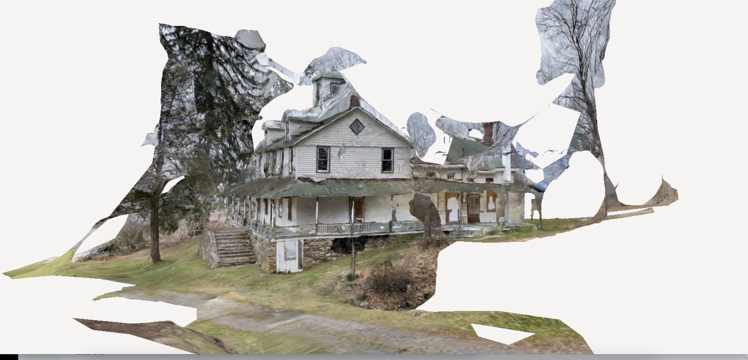
Today, as part of this three part series, I am focusing on the photogrammetric scans in Polycam. For the 3D models, I hoped to collect undistorted, 3D views of the entire structure. This is complicated due to a variety of factors. The best scans required flat light (cloudy days) to minimize shadows from the structures and from surroundings. These scans also need to be collected from the same height for the perimeter, which was difficult due to uneven ground or neighboring structures. Creating scans with high fidelity for size and detail meant finding a distance from the structure to capture the scan that balanced detail and capturing the whole structures: too close meant losing features for the geometry, too far could mean losing detail. Also, as I was often capturing building in a state of decline and decay, the warps, destruction, and missing pieces proved difficult to capture, as did clear glass windows (due to reflections, light, etc) or missing windows. Depending on the level of detail and the size of the structure, changing between Medium and Full processing within the app also changed the fidelity of the scan. Some example scans are below.
Delaware View House/Salamovka. Note the issues with roof features due to my height versus height of structure and the foliage interfering with the scan due to proximity, but also note the detail of the paneling and the stone work on the front steps and lower level.
Lower Treible House/Peters Valley School of Craft. Again, issues with roof but mostly captured due to flat, even 360 path around the house. Additional issues with window reflections and foliage.
Some Polycam Suggestions
-Aim for flat, soft light
-Minimize shadows
-Minimize, if possible, additional elements near what you are scanning
-Use object masking mode for smaller objects (smaller meaning less than person-sized in the author’s experience)
-Chose your detail level based on your objective: I use full because I want a detailed, life-like structure, but for your purposes, optimized or medium may work as well
-For smaller objects (e.g. a ceramic coffee cup), place the object on a uniform (color, texture) surface if you would like to edit it out
-Aim to collect a 360 degree scan and plan your route around the object ahead of time
-Create AT LEAST ONE circle of images at the same height/distance from the object (full 360). As you move 360, collect additional angles of the object (tilt the camera), but always collect an image from the same height/distance for the full 360. Do also remember to collect top and bottom images if you go as possible.
-Remember you can edit individual images out after you collect a scan if you accidentally collect an image you don’t like or contains a finger or person
I am currently drafting a paper based on this work. If you have any suggested journals, please reach out to me via LinkedIn!

